The Essential Guide to Processing UAV Data: Tools and Computer Specs for Handling Large Datasets
UAV remote sensing data, especially from LiDAR, multispectral, or thermal sensors, requires extensive processing to turn raw data into actio


Capture | Process | Deliver


Welcome to Ecko360, your trusted partner in cutting-edge UAV Remote Sensing solutions. Based in Hammond, Louisiana, Ecko360 has been at the forefront of innovation in the aerial and terrestrial data capture industry for over 8 years. Established with a strong foundation in Oil and Gas, we have since expanded our expertise to serve a wide range of industries, including construction, agriculture, environmental monitoring, and more.
At Ecko360, we pride ourselves on delivering precise, high-quality data that empowers our clients to make informed decisions. Our comprehensive suite of services includes Aerial, Terrestrial, and Mobile LiDAR, advanced in-house processing, photogrammetry, orthomosaic mapping, Thermal imaging, OGI and TDLAS Gas Detection, and RGB (Photo and Video) capture. We also offer Matterport 3D Virtual Walkthroughs, providing our clients with detailed, immersive visualizations of their projects.
Our team of experienced professionals is dedicated to harnessing the latest in UAV technology to provide tailored solutions that meet the unique needs of each project. Whether you require detailed topographical maps, accurate volumetric calculations, or advanced thermal inspections, Ecko360 has the tools, technology, and expertise to deliver results you can trust.
At Ecko360, we believe in pushing the boundaries of what's possible, combining our technical knowledge with a commitment to customer service to ensure that every project is completed to the highest standard. We are proud to be a leader in the UAV Remote Sensing industry, and we look forward to partnering with you to turn your vision into reality.
At ecko360 industrial, we pride ourselves on being at the forefront of remote sensing technology. Our team is passionate about providing our clients with unbeatable accuracy and precision, every time. We've spent years developing a custom workflow, validated by engineers and surveyors, and powered by our custom state-of-the-art server. Our server is built to process large, complex data sets quickly and efficiently, allowing us to deliver your project's results in record time, no matter the size.
At ecko360, we are dedicated to utilizing the latest in aerial remote sensing technology to bring the best possible results to our clients. We are a one-stop-shop, which means that you deal with the same team throughout the entire project. From capture and processing to delivery of the final product, we work tirelessly to exceed your expectations. With a reputation for success in even the most challenging of projects and over 30+ years experience we are proud to have a perfect track record.
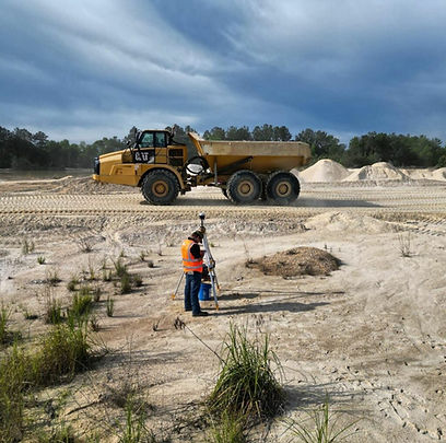
At ecko360, we offer a wide range of remote sensing services using cutting-edge technologies. We specialize in Aerial, Mobile and Terrestrial LiDAR, Photogrammetry, Thermal, Orthomosaic, TDLAS, OGI Gas Detection, Volumetrics, Matterport and much more. Our highly trained team of experts is committed to delivering exceptional results to clients, no matter how complex their project may be. We capture every detail you need.
At ecko360, we pride ourselves on our ability to capture data with unparalleled precision and accuracy. By processing all of our data in-house, we're able to deliver high-quality products at an affordable price point, and we're able to do so in record time. Our team is dedicated to ensuring that nothing falls between the cracks. No matter what type of deliverable you need or what coordinate system you're using, you can trust us to deliver the results you're looking for.


65+
TBs of DATA Processed
500+
Successful Projects
100s
of Satisfied Customers
Million$
Saved by our Clients
8 years
As an Industry Leader

Move your business forward.

Obtain elevation data in any deliverable or coordinate system you want without cutting line.


Ensure your facilities and assets meet EPA regulations. Save money by catching leaks early. Inspect / Spray ROWs quickly.

Avoid costly delays with project documentation by catching issues early or before they happen.

Document all stages of the construction process as it happens online from your desk.

Document as found / as left conditions and inspect facilities quickly.

Get your grid online faster and more affordably after a storm.

Map the entire affected area out to discern which roads are impassible. Calculate storm debris volumentrically.

Keep track of forest health with hyperspectral analysis. Utilize Aerial LiDAR to quickly determine how much merchantable timber you have.

Utilize precision agriculture to keep track of crop health and land topography.

Follow your projects from start to finish with total transparency.
Choose experience and professionalism with Ecko360. Industry leaders in UAV Remote Sensing, Reality Capture and Data Visualization since 2016. Rest assured knowing you can count on the data we provide you each and every time. Our Pilots have experience flying in every situation and will ensure your projects are captured safely and in accordance with FAA regulations.

_svg.png)

ecko360 industrial is the go-to provider for advanced UAV remote sensing services in the Gulf Coast region. Our team of experts has the experience and expertise to deliver accurate, reliable data that can help you take your project to the next level. Contact us today to learn more about our services.


